

Austin Bike Maps & Routes
Maps
- "Austin Bicycle Map" published by
the City of Austin Bicycle Program. Covers about 315
square
miles. Also has a zoomed-out view of the area outside of Austin, and
a
zoomed-in view of the MoPac / W. 5th / W. 6th St. intersection. A
similar version of this map is available online. Where to get it:
Most Austin-area bike shops, or check with the City
of
Austin Bicycle Program.
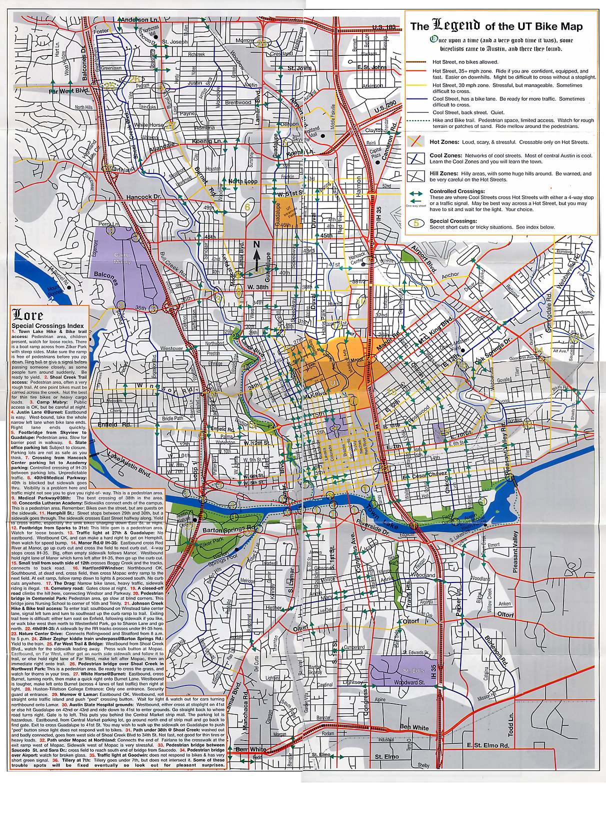
- "Bike Map" published by UT. Covers the central city (about 15 square miles). Even though it's dated (1998), it's an awesome map for the central city, but unfortunately it's been out of print for years, though we've preserved an online version. (JPG 550k)
Trails
- Here are maps of Austin's hike & bike trails
Out of Town routes & maps
- You can find back roads with Google Maps.
- Here's our Austin to San Antonio route.
- Here's a route from Austin to Bastrop.
- For cross-country maps, check out Adventure Cycling.
Routes
If the route you need isn't listed here, then I don't have a route for you. If I knew about the route you were about to ask about, it would be on this page already, since that's the whole purpose of this page. For routes not listed here, ask on the web forum.
* Town Lake Hike & Bike Trail to UT North
(on a
separate page) * Central Austin to IBM * To Austin-Bergstrom International Airport
* Preserve at Travis Creek on SW Parkway, to Mopac & Bee Cave |
East No route information available yet. (Don't misinterpret our lack of route information for East Austin to be a result of bias -- I live in East Austin myself. It's just that I compile & write route tips based on what's requested/discussed on the forum, and a specific East Austin route hasn't been discussed yet. Part of the reason is that East Austin is actually a bit easier to navigate than the burbs up north or south.) Out
Of Town * For regional routes, see our special pages about biking:Other Resources for Route info:
|
Route Details
| Central
Town Lake Hike & Bike Trail to UT
Shoal Creek to Pleasant Valley & Oltorf (per a reader's request) On Shoal Creek going south, make a left on 46th St., and go through the neighborhoods until you pop out on Medical Parkway around 40th. Then you'll have to choose one of these evils: Traffic, Hills, or Distance. More Traffic: Take 38th St. west, go under I-35, take the first right, then go through neighborhoods to get to the intersection of Manor and Chestnut. Take Chestnut South; it turns into Pleasant Valley. More Hills: Take Medical Parkway past Lamar, take the first left (37th?), cross Lamar, catycornering a little to the left (10:00 position) to pick up 37th. When you hit West Ave. 37th stops, but just continue straight through the parking lot to King. Right on King to 32nd, left on 32nd. Cross Guadalupe, and take 32nd all the way to Star Seeds Cafe, which is on the east side of I-35. 32nd is discontiguous so you'll have to keep making little turns to stay on it. It's also very hilly; this was the part I warned you about. Once at Star Seeds, go through neighborhoods to get to the intersection of Manor and Chestnut. Take Chestnut South; it turns into Pleasant Valley. More Distance: Take Medical Parkway past Lamar, take the first left (37th?), cross Lamar, catycornering a little to the left (10:00 position) to pick up 37th. When you hit West Ave. 37th stops, but just continue straight through the parking lot to King. Go left a tad on King, until you can pick up 37th again on the right. Make a left onto Guadalupe (or take the sidewalk to the 38th/Guadalupe intersection if that left turn frightens you). From the SE corner of Guadalupe & 38th, go north to cross 38th, get on the sidewalk, and make an immediate right onto 38 1/2 St. Left on Ave. B to 42nd, right on 42nd to Duval, take a catycorner left on Duval to pick up Park St. and continue west. Blast down the hill on Park and you'll pick up enough speed that the uphill on Park will be easy. Park dumps you out onto Red River at Hancock Center. Right on Red River, cross through the light at 41st, left on 40th, right on Wilbert, left on 39th, right on Harmon, left on 38th, go under I-35, take the first right, then go through neighborhoods to get to the intersection of Manor and Chestnut. Take Chestnut South; it turns into Pleasant Valley.
Avoiding traffic light at Koenig The light at Koenig & Guadalupe is long. If you want to avoid it, then cross Koenig on Chesterfield instead of on Guadalupe. North of Koenig, go between Guadalupe and Chesterfield by riding over the pedestrian foot bridge. Guad- West Preserve at Travis Creek on SW Parkway, to Mopac & Bee Cave (by Robert M. Farr, 3-00)
The big mountain on 2222 This one is addressed on its own page |
South
To Austin-Bergstrom International Airport There is no safe route to the airport,, because the last mile or two is on a shoulderless road with 70 mph traffic. However, the #100 bus goes straight to the airport from both UT and downtown, and costs only 50¢, and the bus has a rack you can put your bike on. Here's a link to the bus route schedule. There are bike racks in the airport parking garage. Westgate Cinema/Central Market (by Ken Marsh) Last weekend I made my first bike ride to the Westgate cinema which is in the new single-story-shopping-center-mega-sprawlplex which includes the new Central Market store. To get there, I survived crossing the Lamar/71/290/360 cement octopus! From a distance, this "intersection" looks to me like it was designed to kill cyclists (insanely complicated and overbuilt design, no Lamar sidewalks, no shoulders, confused & speeding motorists anxious about getting on or off one of 3 highways). Actually I cheated a little to cross 71. Instead of staying on Lamar and dealing with all the weird traffic patterns, I used the northeast and southeast shopping center parking lots and sidewalks to cross the 71 frontage roads and central gravel wasteland under 71 just east of Lamar. It was stress free, quick, and easy - just a few curbs to hop. I saw a lot of children doing the same thing on their bikes. I recommend this eastern route. By the way, I was happily amazed at the number of brand new bike racks that are embedded in the sidewalk all around this shopping center. There were at least 15 low profile, single-occupant racks outside the theater, a bunch more around the corner and another 10 or so outside C.M. A reader writes: "I'm looking for the safest bike route from downtown Austin to the corner of 1626 and Manchaca." Bluejay responds: The bike map published by the city is often good for routes like this. It shows a circuituous route using several different streets for this trip, exclusively on blue/green (safer) roadways --- until you get to Slaughter & Palace, where you're stuck. There does seem to be a neighborhood south of there, though, and maybe with a regular street map (or maps.yahoo.com), you can find enough neighborhood streets for the rest of the trip. Dave Dobbs (ddobbs-at-realtime.com) responds: There really is no safe route a half mile south of Slaughter Creek where Manchaca Road narrows just past two subdivisions that straddle the road. Any route through the neighborhoods south to Manchaca Road south of Matthews Lane will put you onto very wide striped safety lanes on Manchaca until it narrows south of Slaughter Creek. I live just east of Manchaca and Slaughter and ride all over the area, but will not ride south of the road narrowing on Manchaca as the shoulder is narrow and the cars very fast.
Ben White & I-30 Lane Wayport (lane -at- wayport.net) writes on July 23, 2004: My new commute is to the south-east corner of Ben White and I-30, just off of Freidrich Ln. to be more precise. I see two route options that on my Austin Bike Map, but which is better? The first one, which I test-rode a few weeks back, is down East Side, across the St. Edwards campus to Woodward, where I turn east to cross both I-35 and Ben White (the intersections with which are nasty, strewn as they are with nails and broken glass, and lacking as they do dedicated bike facilities, which forces one up onto the sidewalks for stretches). The other option that I just noticed is to continue east on Annie/Woodland across I-35, where it appears there's a controlled crossing of I-35 as opposed to the non-controlled crossing at Woodward), to turn south on Parker Ln. Parker then heads all the way down to Woodward, where I'm still faced with crossing Ben White, but the time spent on (the nasty section of) Woodward would be roughly halved. Each of these maps shows these two routes: City's Bicycle Program, Austin Chronicle tim_allison -at- mail.utexas.edu responds: I've ridden several times on Woodland and Parker -- it's much safer to cross I-35 on Woodland and there isn't much traffic on either Woodland or Parker. That's the route I'd recommend, although you'll have to face a few more hills, especially on Woodland. bobfarr -at- austin.rr.com responds: Woodland and Woodward each have their plus and minus points. I'd opt for whatever option kept me on East Side Drive as long as possible. That's the sweet street, particularly if you can include the Travis Heights greenbelt as part of your commute. What a hidden treasure that is. Phil Hallmark responds: I got this from Paul Crocker, friend of mine who used to commute in that area: I commuted from Rollingwood to Freidrich Ln. twice a week for an 18-month period. I was also fearful of the route at first, but later found it to be a very enjoyable ride. I rode the north side of town lake to the east side of I-35 where I crossed the river on the pedestrian bridge. From there I took Riverside to Parker Ln, which I took all the way to Woodward. Parker Lane is hilly and an excellent workout. It is also a 30mph road, and I never felt threatened there. As you said, Woodward was stressful. Sometimes I choose the sidewalk, but usually just tried to ride fast since I was on it for such a short time. The Ben White crossing is totally different now so I cannot comment. The other dangerous spot was crossing Riverside. There is a light, but there is also a "yield lane" with lots of traffic. On Riverside I used the south sidewalk for both directions. I would not consider using the traffic lane on Riverside.
Dripping Springs to Oak Hill (by bobfarr -at- austin.rr.com) From Dripping Springs take Fitzhugh Road all the way till it doubles back to 290. Take 290 eastward about 100 yards and immediately take the left onto Circle Drive. Take Circle Drive almost all the way back to 290 but instead take the left onto Thomas Springs Rd. A few miles later cross straight over Highway 71 and you are now on Old Beecave Rd. You can follow Old Beecave road all the way back to 290/71 and then have only about a quarter mile of 290 to deal with before it turns into a freeway where thankfully, the service road is quite safe and rideable. Congratulations, you made it from Dripping Springs to the Austin city limits via the safest (and most pleasant) route available. You can ride thru the city or take 360 north. Dripping Springs to Bee Cave (by ) From Dripping Springs, again, Take Fitzhugh Rd the same direction as before. This time, turn left at Crumbley Ranch Rd. (my favorite "close-in" hill country road.) Crumbley Ranch Rd ends back at Hamilton Pool Rd (3238 -getting more dangerous every day thanks to sprawl) where you must survive a continuous stream of both the good 'ol boys and new age country suburbanites screaming by you at 80 MPH until you get to Hwy 71 just west of Beecave. At least Hwy 71 has a decent shoulder where you can get to 620 for the long haul north or go a bit farther east to 2244/Beecaves Road and make your way through town or ride 360 northward - your choice. |
Last update: January 2016