This route was decent at 7:30-8 am on a Saturday morning.
There was a bit of a tight squeeze near I-35.
Arboretum Blvd. has a big hill, but your alternative
(Great Hills Trail) has an even bigger hill and more
traffic. A third option, to skip both hills, is to go the
wrong way on the 183 frontage as a pedestrian, carrying your
bike and being very careful.
You might be tempted to take the long version of the hill
to the right by the duck pond but I found that the short
hill straight ahead is better. Arboretum Blvd. eventually
goes to a 4-way stop with Jollyville right in front of the
Renaissance Hotel. Turn left here and then you're set to go
straight on the green light across Great Hills.
- You can take Jollyville, which is a straight
shot, but the road lanes are narrow and the traffic is
fast. You can get to Jollyville by first going south on
the 183 frontage road, crossing 360, then hanging a right
about 200 yards after 360. If you're wary of staying on
the frontage road after crossing 360, then see the map image with a red line
showing where you can walk your bike.
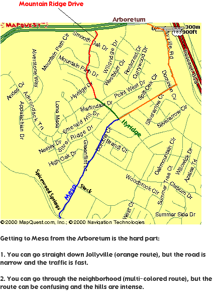
- You can weave through the neighborhood between 360
& Mesa but the route can be confusing, and the
hills there are BAD. Check out the second map image. In words: (A) Go south on 360, pick up
Mountain Ridge Drive. (B) After half a mile, left on
Hyridge. (C) After a quarter mile, left onto Mesa.
However you do it, once you get to Mesa, it's much
less difficult. Here are two options:
Safer & less hilly, but circuitous
- (1) South on Mesa. Mesa has a bike lane, if I
remember right.
- (2) 1.5 mi., then Left (east) on Spicewood
Springs.
- (3) 2 mi., then Right (south) on Shoal Creek.
- (4) 4 mi., then Left (east) on 46th St.
- (5) 4 blocks, then Right (south) on Rosedale.
- (6) 5 blocks, then Left (east) on 40th.
- (7) 3 blocks, then Right (south) on Medical
Parkway.
- (8) 4 blocks, then Left (east) on 37th St.
(immediately after big 38th intersection)
- (9) Note that 37th is discontiguous at Lamar. You
go catty-corner when crossing.
- (10) Where 37th ends after another block, continue
straight through the medical parking lot.
- (11) Right (south) on King St. when you exit the
parking lot.
- (12) Right (west) on 31st, then immediate left
(south) onto Washington Square.
- (13) As you cross 29th, you'll have to go
caty-corner to the left to get on Salado.
- (14) Left (east) onto 28th St.
- (15) 3 blocks, then Right (south) onto
Nueces.
- (16) 2 MILES, then left (east) on 5th St.
(17) Continue on 5th St. a few blocks into
downtown
Simpler, but more traffic and more hilly
- (1) South on Mesa. Mesa has a bike lane, if I
remember right.
- (2) 1.5 mi., then Left (east) on Spicewood
Springs.
- (3) 2 mi., then Right (south) on Shoal Creek.
- (4) 5 mi., then Left (east) on 38th St.
- (5) 1 mi., then Right (south) on Guadalupe
- (6) 1 mi., then take the fork on the right
(Nueces), right across the street from Mango's.
- (7) 2 miles, then left (east) on 7th St.
- (8) Another half mile on 7th. and you're in the
heart of downtown.
-
- To go the opposite direction, take Rio Grande
between MLK & 28th instead of Nueces.
Bill Canfield offered this
modification, a way to avoid going through the busy
intersection at Anderson & Shoal
Creek.
- I'm excited about a detour I just found that lets you
avoid any contact at all with Anderson/Spicewood, by
going under Anderson. Cross Mopac at Steck, and go south
on Shoal Creek. Take the last right before Anderson,
heading toward the grape-cluster sign for Grapevine
Market. Just stay on that street as it curves south. It
dead-ends, but there is a usable path under the overpass,
which puts you into the parking lot of the office
buildings at Shoal Creek and Foster. Stick to the outer
perimeter of the parking lot, and you'll be back on SC
after having avoided the traffic crunch south of
Anderson.
- Caveats:
-
- 1. There are car tracks on the shortcut. I haven't
seen any cars there, but keep your eyes open.
-
- 2. Watch out for highwaymen and trolls under the
bridge at night.
-
- 3. Doesn't work as well in the other direction (I
hate going up the hill on Steck). I prefer taking
Spicewood Springs to Mesa, though others like Far
West.
620/Parmer to LCRA on Lake Austin Blvd.
Monica Beard writes on 5/11/05: I want to bike to work, but
I'm finding it difficult to find a safe route from 620 /
Parmer to LCRA on Lake Austin Blvd. Some of the routes that
are marked on the city bike route map, have no bike lanes or
the lanes end when there are hills, etc.. Just trying to get
to work in one piece and would appreciate any help.
Joel Sumner replies:
That's a pretty long way but I can give you help
on part of the route.
(1) Do you feel comfortable riding on Parmer?
If so, I'd:
- Take Parmer all the way to Amherst (just before
MoPac).
- Take a right on Amherst. (map)
- Then take a left on Adelphi
- Then a right on Waters Park (no shoulder but I
never see much traffic on it). It turns into Park Bend
Dr when it goes under MoPac.
- Take a right on Metric and take Metric south.
- Make a left on Rutland.
- Wind through the neighborhoods to get to Peyton
Gin (map)
- Head south on Ohlen Rd. You can either cut over to
Shoal Creek from there or head down Woodrow.
(2) If you don't like Parmer, then
- Take Parmer just to Anderson Mill Road.
- Head West on AM Road until you hit 183.
- At this point AM Road gets gnarly so head south on
the US 183 access road for about 5 feet, duck into the
gas station and head south through that strip mall
parking lot until you hit Balcones Club Drive.
(map)
- Then follow this
route to Jollyville which can take you to loop
360
Kristin Theiler adds:
I'm sure someone else probably has a route with
fewer roads, but here's one continuing from Jollyville. I
highly suggest driving a new route first at the time of
morning you anticipate riding to ensure the traffic seems
safe enough for you. You won't be able to get to
Jollyville/Mesa going this way, but you can take a right
onto 360 and do a uturn to get there.
- Take Jollyville until it ends in the
Arboretum
- Right on Arboretum Blvd
- Cross 360 and go left/east
- Right on Jollyville
- Right on Mesa
- Follow city bike route from Mesa onto Sierra, etc
to get yourself to Balcones
- Balcones south all the way to 35th (never ridden
Balcones in the a.m. so unsure on traffic)
- Jog Left on 35th, then Right on Pecos
- Right on Scenic (when I rode this route a couple
weeks ago the Scenic sign was missing or hidden so
look on the map - it's right as you're part way up the
1st hill)
- You'll take another Right to stay on Scenic by
Matthews
- Left on Stevenson
- Right on Rockmoor
- Right on Cherry Lane which turns into Lake Austin
Blvd and you're right by LCRA
North > North
Burnet to Metric, north of 183
by Ken Marsh
From Burnet you can take a shortcut through my industrial
park to get to Metric. Just north of 183, take the small
road that veers off to the right (north-northeast). Continue
straight when this road curves left, and enter a huge area
of one-story modern warehouse/offices. Follow the parking
lot in front of the first warehouse and you will see
Rundberg Lane. Take that east across the railroad tracks
then make your way north and east through warehouse parking
lots -- you will eventually get to Rutland and Metric.
Continue north on Metric.
Pflugerville to IBM (Burnet/Braker)
by Brian Horton
I live in Pflugerville as well, and bike commute to
the IBM site (Burnet/Braker) every day. From
Pflugerville, my route is:
- Back roads to 1825
- Past the HEB onto Wells Branch
- Stay on Wells Branch under 35 to Thermal
- Left on Thermal, which becomes Metric when it crosses
Howard Lane
- Metric all of the way to Gracy Farms
- Gracy Farms to the IBM bldgs
...and back to Pflugerville the same route (IBM to
Gracy Farms, Left on Metric, Right on Wells Branch, Left
on 1825 into Pflugerville). Total length from IBM to the
HEB is about 7 miles.
Metric isn't all that friendly and not for the timid
or meek -- not much of a shoulder in most spots. But it
is 2 lanes each way which gives the cars a bit more room.
Traffic isn't usually that fast, and in fact, on the
afternoon rides its so backed up in spots, I usually pass
the same cars at several of the lights.
Another option might be Dessau road, which they just
finished widening up to Pflugerville. It starts up there
East of town and comes down all of the way to 183. I've
done that route home several times -- IBM to Braker to
Dessau to Pecan Street into Pflugerville. Again, 2-3
lanes, little to no shoulder. And its higher speed than
Metric. But do-able.
Not much else to suggest. I'd be interested in
hearing if anyone else has any other routes! Oh, and if
you leave Pflugerville around 7:15am, we might see each
other!
Avery Island (McNeil/Parmer) to Duval/Mopac
John Benner writes: I am
trying to find a reasonably safe bicycle route to take me
from Avery Island (off McNeil Drive, near the
intersection of Parmer and McNeil) to my workplace, near
the east side of the intersection of Duval and Mopac.
Allan answers:
From your place, get on Riata Trace. Head toward 183.
Just before 183, make a right turn at the last little
intersection. Go forward 1/4 block to the 4 way
intersection.
Make a left turn, and follow the winding road through
what used to be TI, now I think its Solectron. Follow
this 20mph road for 1/4 mi till the intersection. Make a
left. This is Oak Knoll. Get in the right lane, and take
the whole thing up. Cross under 183, cross Jollyville rd,
then make uturn when safe. Get on Jollyville south bound,
make left onto Duval. At intersection of 183, take whole
lane. Head east on Duval, you will reach school zone 200
Yards east of 183. You will have 3 ft stripe until just
before RR tracks. As you approach RR tracks, look back,
if clear, move out past the stripe, and take up some
space. If you skip this part, you will get to be a human
slalom pole where Duval becomes 2 lanes.
Jump the RR tracks, and continue east til Amherst. At
Amherst, you need to decide whether or not you will take
the lane. I recommend you do. Watch out for the manhole
covers!! There are 3 or 4 between Amherst and Mopac. They
can put you in the air.
Depending on when you ride, Duval will be stopped up
from Mopac almost to Amherst. Use your good judgement as
to when to take the lane, if you even want to. As has
been mentioned, Duval between Amherst and Mopac has a
sidewalk on the east bound side.
I would strongly recommend you either use the
sidewalk or take the whole lane between Amherst and over
Mopac.
The way back is harder. Duval between Mopac, and
Amherst at rush hour is unpleasant. Haul Ass, ride like
you mean it, or get on the sidewalk. The sidewalk has a
barrier a little past Time Warner. It's an auto crash
barrier, but it will gradually squeeze the rider off the
sidewalk onto Duval Rd. This happens just before
Amherst.
Past Amherst, no problem till Duval west bound and
183. At that point, watch your back, and take the lane.
Cross under 183, right on Jollyville. Go North till Oak,
Knoll, make another right, cross under 183 again, go into
the technology park, make the first right, and find your
way back to Riata Trace.
There are a series of roads you can ride on between
Oak Knoll and Duval that parallel Jollyville. They are
hard to describe. Look on a current map for the street
called Woodcrest. When you can find those streets, you
will like them better than Jollyville.
Another option: illegal/immoral/criminal, On Riata
Trace, the buildings nearest 183. There is a cyclone
fence gate that on the other side is west cow path. Many
of those Riata office park buildings are now unoccupied.
Nuf said.
Wells Branch to Dell
Dennis Abbot writes in Dec. 2004:
Well, I started riding my route on Wednesday.
I'm pretty close over in Wells Branch and I just shoot
through Grand Ave Parkway(long light under i35) and then
take the feeder as suggested to the Target parking lot.
That parking lot is totally empty in the mornings. 4.5
miles one-way and I get there 5 minutes quicker than by
car. Lots of cars to deal with but they are all going
about 5 miles an hour. I don't see how these people can
sit in a car that long. Return trip is a little scarier.
Suprisingly Dell has no bike racks, showers cost you $14
a month, and there is no shuttle to campuses outside of
the RR campus(I need to go to Parmer once a week at
least). If there was a cap metro bus stop near any part
of that RR campus I would live in central Austin in a
second. There is a bus (495?) that hits the Parmer campus
but then I would still need to get to RR and the Dell
shuttle does not run to Parmer.
Wells Branch to Rutland/Burnet
DLHughes001 asks in March 2005:
I'm new in town, will be living in Wells Branch,
working on Rutland right off Burnet Rd. Looking at Yahoo
maps, I see that a possible bike route to work would be,
from W.B. Pkwy, Thermal Dr. (which turns into Metric at
Howard), all the way down to Rutland. The city's bike map
declares this road to be for experienced urban cyclists
only. I have some city-riding experience from Houston, so
it can't be any worse. Any of you who ride that road,
what's your take on it? Would it be a good way to get
from Wells Branch to Rutland/Burnet Rd.? Is there a
better way?
Joel Summer replies:
I find Metric ok between Parmer and Kramer.
Metric from Kramer to Rutland is not much fun. Heading
South is ok because it is downhill. North is uphill, the
wide (or very wide) shoulder is not there, road is much
bumpier. Instead, you might cut through the office park
West of Metric (off of Boyer)
Rick Byrnes adds:
I take Thermal Drive, and Metric from Howard to
Parmer, when I bike commute to work. Thermal Drive is
decent to ride on. Goes by an elementary school with a
speed zone. Metric Blvd recently got painted bike lines
from Howard Lane down to Parmer. It's safe to ride. The
Austin city bike map probably hasn't been updated for it
yet. If you ride north through the Metric/Howard/Thermal
intersection during the afternoon rush hours, northbound
traffic often backs up at that intersection and you have
to get into the center lane to go straight through. But I
don't recall if Metric below Parmer got the stripes. That
portion of Metric has a good number of commuter vehicles
using it, so without bike lanes I would consider it a bit
rough. You'll need to ride defensively.
Kevin Corry adds:
I ride along parts of Metric almost every day.
Taking Thermal isn't bad - it's just two lanes and pretty
wide, so you shouldn't get too crowded. Then when it
turns into Metric, there are fairly new bike lanes all
the way down to Cedar Bend, where they just randomly end.
Unfortunately, to get where you're going, you'll really
need to continue down Metric past Cedar Bend and across
the bridge at the bottom of that hill. Metric is four
lanes divided and not very wide, so you really need to
take the lane down that hill. Once you get past the small
bridge, if the traffic is too much for you, there's a
sidewalk that goes up the next hill on either side of the
street.
Then, instead of continuing down Metric all the way to
Rutland, I'd suggest turning left across Metric (you may
have to wait awhile for a decent gap in traffic) onto
Bittern Hollow, which is next to the big church at the
top of the hill. Then turn left onto Parkfield Dr, which
is a few streets after Gracy Farms. Parkfield will cross
Braker and Kramer. Once past Kramer, you can go all the
way down to Rutland, or alternatively snake you're way
through the neighborhoods in that area and come out on
Rutland at Quail Valley or Golden Meadow (see
maps.yahoo.com for all the details). Then you can head
back west on Rutland until you get to your office. I
haven't ridden on Rutland in a while, but I don't
remember it being very bad. All of this might be a little
bit out of your way, but it probably beats riding on
Metric, especially since you'll be riding up hill all the
way to Braker. Good luck!