|
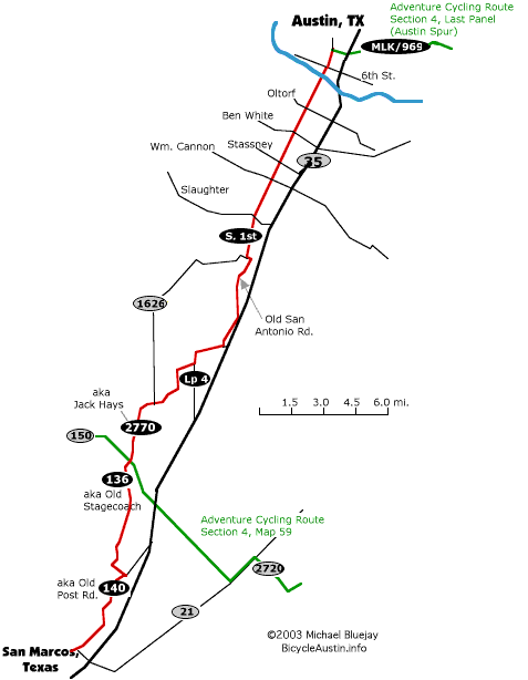
We originally wrote this page to provide an alternative to the cross-country route published by Adventure Cycling as it approached Austin. In the meantime Adventure Cycling has adopted our suggestion and now lists it as Map A on map booklet #4. We're leaving this page up for cyclists who have the old Adventure Cycling map and want an alternative.
The old AC map had cyclists bypass Austin by cruising west to east at about 25 miles below Austin, and suggested that if you wanted to visit Austin you take a "spir" route into Austin when you get to Bastrop. But that means you would have to do the spur twice -- once into Austin, and once back out to Bastrop. Between the doubling back and the longer Adventure Cycling route to Bastrop in the first place, this adds 57.2 miles to your trip (vs. taking our route into Austin). In fact, our route is so efficient that even if you hadn't planned on going into Austin at all, going through Austin anyway with our route will add only six miles total to your trip! The other problem with going between Austin and Bastrop twice is that the riding on that route isn't so great, with vehicles passing at insane speeds on a narrow roadway with no paved shoulder. You'll do that once with our route, but with Adventure Cycling's old spur you'll do it twice. To take our route, just leave the old Adventure Cycling route at 150 & 2770 near Kyle, Texas and head north 25 miles into Austin. Once you've had your fun in Austin, you can continue on the Adventure Cycling route by taking the spur directly from Austin to Bastrop. You'll be taking the red line in our map. (The reason the red line also goes south of 150 is that this map also serves as a route between Austin and San Marcos.) Click on our map at right for a printer-friendly version. A cue table appears below. Note: Adventure Cycling's new map A is mostly like our map below except starting at Slaughter lane they have you take Congress Avenue instead of S. 1st Street . On further reflection, Congress is probably the better choice. It's not depicted on our map below, but it's easy to find: Congress is about a mile east of S. 1st, and runs parallel to it. The easiest way to get to it is:
Once you're in Austin, you might benefit from: |